
Section 2 · Trail Info
Ways to navigate your way around the Historic Mine Route
The full Historic Mine Route loop is about 7 miles, with shorter hike options and chairlift shortcuts for visitors with limited time or mobility. Free navigation tools also help you follow the HMR and explore Park City’s history at any or all of the 24 mining sites along the way.
The Route
Routes at a Glance
Hike the Full HMR Loop
Bike the Full HMR Loop
Lift to Silver King Mine down via Empire Canyon
Out and Back to Empire Canyon
Navigate Your Way
Free tools for staying on the right trails
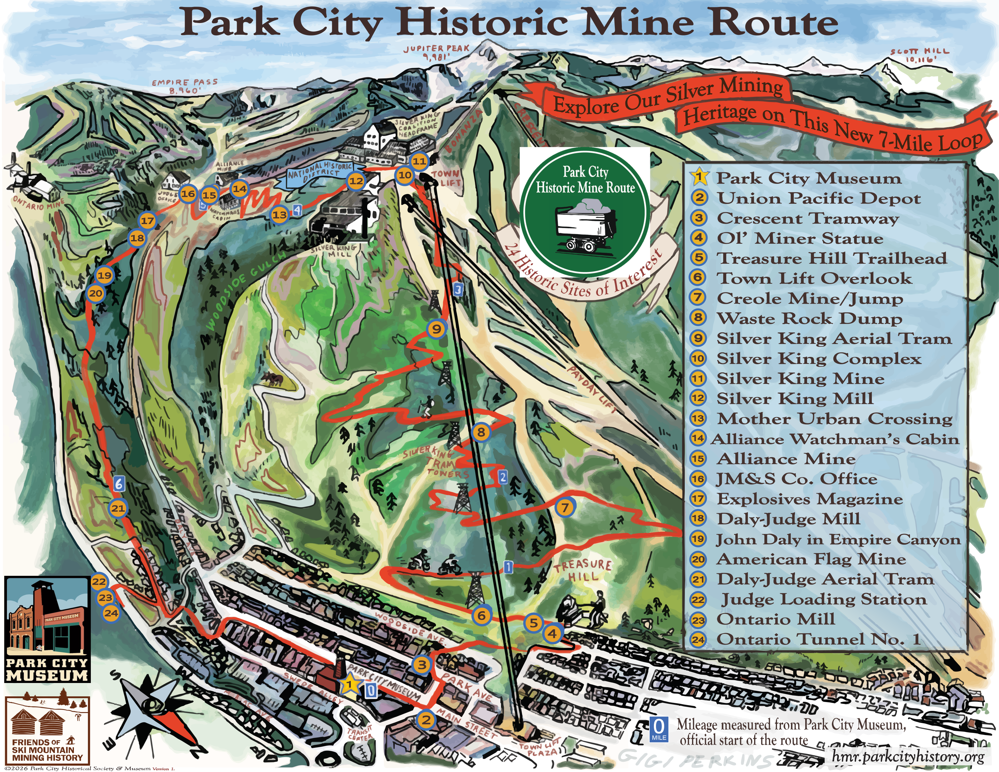
Route Options
Four ways to hike or bike it
More detailed descriptions of each route option are included below. Click on “Route Details →” to read guidelines step-by-step from start to finish, and…
- A list of all the trails that will be encountered with their relative difficulty ratings
- A link to a topographic map of the route in the AllTrails GPS navigational app
- A printable 1-2 page summary overview of the route in PDF format
- A link to download a universal GPX (GPS Exchange Format) file of the route that can be used in different GPS navigation apps of your choice, such as Gaia GPS, TrailForks, Strava or Avenza
Enjoy the Park City Historic Mine Route!
The Full Loop
The complete counterclockwise circle — start and finish at Park City’s Museum.
Hike the Full HMR Loop
The signature experience. From the Museum, travel counterclockwise past all 24 historic sites — up Sweeney's Switchbacks to the Silver King Complex, then down through Empire Canyon and Ontario Ridge back to Main Street.
Bike the Full HMR Loop
The hikers’ route adapted for mountain bikes on multi-use trails, with marked detours around the hikers-only sections of the loop.
“Moderate climbing and fun downhill sections… recommend for intermediate and up riders.” — a team member who rode the loop
Chairlift Shortcuts
Ride up, hike down or ride the lift back down. There is a charge to ride the chairlifts unless you have an active Epic Pass.
Lift Up, Continue Through Empire Canyon
Ride up from Main Street on the Town Lift or from the ski resort’s Mountain Village on the Payday Express, visit the Silver King Complex, then keep going — down through one of the densest sections of old mining structures in Empire Canyon, ending back at the Museum.
Empire Canyon Direct – Out and Back Hike
Shorter routes focused on the Daly-Judge and Alliance mine sites — the densest cluster of structures on the Route.
Out and Back to Empire Canyon from the Museum
Walk uphill on Main Street from the Museum, following the HMR signs clockwise up Ontario Ridge to the Empire Canyon sites — the Ontario Mine stories, the Daly-Judge Mill, and the Alliance buildings.
Ready to explore?
528 Main Street
or Swede Alley
558 Swede Alley
iPhone & Android
Before You Head Out
Download the free TravelStorys audio guide
Whichever route you choose, download the app before you go and set location to "always allow" — the stories at all 24 sites of historic interest play automatically as you approach, even if your phone falls asleep.
Also viewable on desktop at travelstorys.com